Filtered by:
- Category
- List
- Grid
A subscription to the Price Guide is required to view results for auctions ten days or older. Click here for more information
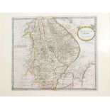

After Morden. Map of Lincolnshire, first edition, originally published in Camden's Britannia, in col
After Morden. Map of Lincolnshire, first edition, originally published in Camden's Britannia, in colours, c1695, 37cm x 43cm.
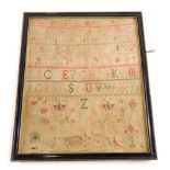
A Victorian alphabetic and numeric sampler by Mary Ann Aidsaill, 1846, 41cm x 33cm.

After Sidney and J Richards. Guernsey, Herm and Sark Channel Islands, printed map, in two parts, eac
After Sidney and J Richards. Guernsey, Herm and Sark Channel Islands, printed map, in two parts, each 103cm x 71cm, an English Channel standard ch...

By Kip and after Saxton. Map of Lincolnshire 1607, first issued map of Lincolnshire, Latin text vers
By Kip and after Saxton. Map of Lincolnshire 1607, first issued map of Lincolnshire, Latin text verso, c.1607, 30cm x 35cm.

After Jansson. Map of Lincolnshire, Latin text verso, published in the first edition of Atlas Amster
After Jansson. Map of Lincolnshire, Latin text verso, published in the first edition of Atlas Amsterdam, c.1646, 40cm x 52cm.

After Mercator. Regional map, Yorkshire, Notts, Derbyshire, Lincolnshire, Norfolk and Staffordshire,
After Mercator. Regional map, Yorkshire, Notts, Derbyshire, Lincolnshire, Norfolk and Staffordshire, with original hand colour and French text ver...

After Saxton. Map of Lincolnshire amended by Philip Lea, with early and later hand colouring, c.1693
After Saxton. Map of Lincolnshire amended by Philip Lea, with early and later hand colouring, c.1693, 42cm x 54cm.

After Speed. Map of Lincolnshire, early edition with English text verso, with later hand colouring,
After Speed. Map of Lincolnshire, early edition with English text verso, with later hand colouring, circa 1627, 40cm x 50cm.

After Speed. A Saxton Heptarchy map, of Britain, English text verso, c.1627, 39cm x 51cm.