Filtered by:
- Sale Section
- List
- Grid
A subscription to the Price Guide is required to view results for auctions ten days or older. Click here for more information

Africa. A collection of 15 regional maps, 16th - 19th century, engraved and wood block regional maps and city plans, including examples by or afte...
Bellin (Jacques Nicolas). L' Hydrographie Françoise Recueil des Cartes Générales et Particulieres..., Premiere Partie, Paris, 1756, additional dec...
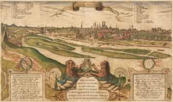
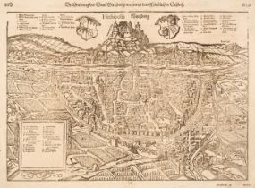
* Braun (Georg & Hogenberg Franz). Monachium Utriusque Bavariae Civitas Primar, circa 1580, engraved city plan of Munich, contemporary hand-colour...
British County Maps. A collection of 25 maps, 17th - 19th century, engraved county & regional maps, town plans and road maps, including examples b...
British County Maps. A collection of approximately 85 maps, 19th-century, engraved county maps, many with contemporary colouring, including exampl...
British Isles. A collection of approximately 100 maps, mostly 19th & early 20th century, engraved, lithographic and photolithographic maps of the ...
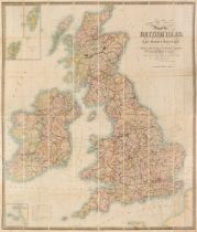
British Isles. Walker (J. & C.). Map of the British Isles Showing the Cities, Borough & Market Towns, The Principal Villages, Railways, Mail & Tur...
![Cardiganshire. Speed (John), Cardigan Shyre Described..., 1st edition, [1611]](https://portal-images.azureedge.net/auctions-2023/srdom10230/images/bdfa93ed-3cb1-4e53-a119-b0cb010befc1.jpg?h=210)
Cardiganshire. Speed (John), Cardigan Shyre Described with the due forme of the Shiretown as it was Surveyed, 1st edition, John Sudbury & George H...
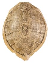
* Cartographic Curiosity. Cook (Captain James). Resin faux turtle shell with 'scrimshaw', 20th century, 18th Century style resin "scrimshaw" faux ...
Cary (C. & J.). Cary's Improved Map of England and Wales with a considerable Portion of Scotland, Planned upon a Scale of Two Statute Miles to one...
![China. Mercator (Gerard). China, [1606 - 1630]](https://portal-images.azureedge.net/auctions-2023/srdom10230/images/6819d2eb-1ad8-40b1-b82e-b0cb010bf146.jpg?h=210)
China. Mercator (Gerard), China, [1606 - 1630], engraved map with contemporary outline colouring, insular Korea, large margins, margins with sligh...
![China. Ortelius (Abraham), Chinae olim Sinarum regionis nova descriptio..., Antwerp [1592]](https://portal-images.azureedge.net/auctions-2023/srdom10230/images/dea82803-5e02-4cce-9373-b0cb010bf1c0.jpg?h=210)
China. Ortelius (Abraham), Chinae olim Sinarum regionis nova descriptio, auctore Ludovico Georgio, Antwerp [1592], engraved map with bright contem...
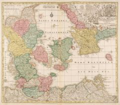
Denmark. A collection of 40 maps, 17th - 19th century, engraved country and regional maps, city and battle plans, including examples by or after L...
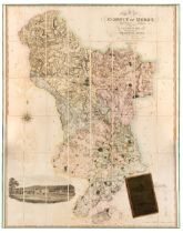
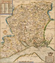
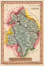
Derbyshire. (Greenwood (C. & J.), Map of the County of Derby, from an actual survey made in the years 1824 & 1825..., Greenwood, Pringle & Co., De...
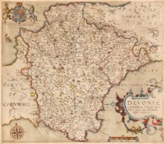
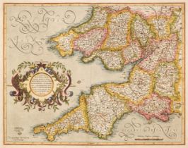
* Devon. A collection of 18 maps. 17th - 19th century, engraved county maps, including examples by or after Saxton/Kip, Osborne, Van den Keere, Pe...
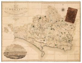
Dorset. Greenwood (C. & G.), Map of the County of Dorset, from an actual survey, made in the years 1825 & 1826..., published Sept. 11th 1826, larg...
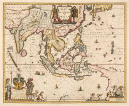
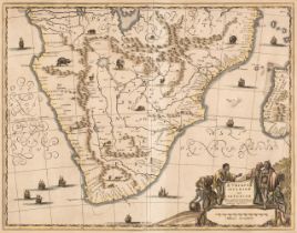
East Indies. Blaeu (Willem Janszoon), India quae Orientalis dicitur et Insulae Adjacentes, circa 1640, hand-coloured engraved map, decorative cart...
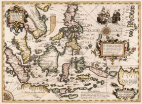
East Indies. Mercator (Gerard & Hondius Jodocus), Insulae Indiae Orientalis Praecipuae In quibus Moluccae celeberrimae sunt, Amsterdam, [1606 - 16...
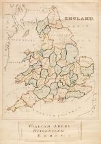
England & Wales. Abery (William), England, Hungerford, 'Midsummer' 1846, large manuscript map in ink and watercolour, slight spotting and staining...
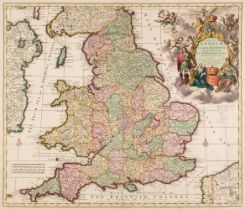
England & Wales. Allard (Carel), Regni Angliae et Walliae Principatus Tabula divisa in LII Regiones Anglice Shire dictas..., Amsterdam, circa 1689...
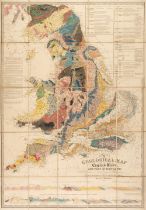
England & Wales. Walker (J. & C.), A Geological Map of England, Wales and part of Scotland, showing also the Inland Navigation with the Rail Roads...
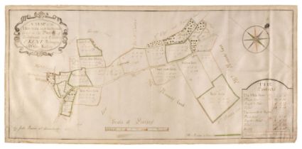
Estate Plan. Bowra (John), A Map of the Hole Farm and the Sprouds lying in the Parish of Speldhurst in the County of Kent, Belonging to Dr George ...
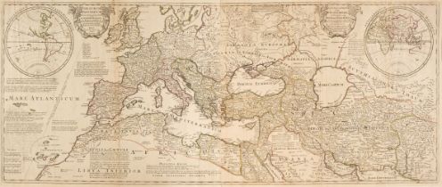
Europe. De L'Isle (Guillaume), Theatrum Historicum ad Annum Christi Quadringentesimu in quo tum Imperii Romani tu Barbarorum..., / An Historical M...
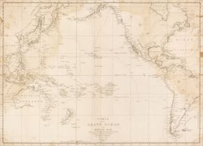
Folding Maps. Fullarton (Archibald), A Collection of Eight Maps: United States North Eastern Section, United States South Central Section, North A...
Foreign Maps. A collection of approximately 70 maps, mostly 18th & 19th century, engraved regional and country maps, sea charts and city plans, in...
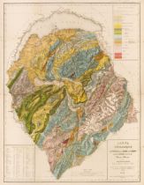
Geological Map. Favre (Alphonse), Carte Géologique des Parties de la Savoie, du Piémont et de la Suisse Voisines du Mont Blanc..., J. Wurster et C...
Germany. A collection of approximately 70 maps, 16th - 19th century, engraved and woodblock country and regional maps and city plans, including ex...
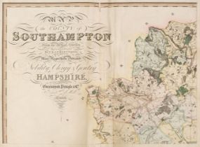
Hampshire. Greenwood (C. & J. and Kentish N. L. publishers), Map of the County of Southampton from an Actual Survey made in the Years 1825 & 1826,...
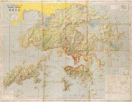
Hong Kong. The Territory of Hong Kong, published by the Director of Military Survey, Ministry of Defence, 1986, colour printed folding map, inset ...
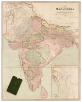
India. Walker (John), This Newly Constructed and Extended Map of India from the Latest Surveys of the Best Authorities Published Principally for U...
![Ireland. Speed (John), The Kingdome of Irland..., Thomas Bassett & Richard Chiswell, [1676]](https://portal-images.azureedge.net/auctions-2023/srdom10230/images/7dc01283-b7f6-46f8-96ce-b0cb010bfc55.jpg?h=210)
* Ireland. Speed (John), The Kingdome of Irland Devided into Severall provinces and then againe Devided into Counties Newly described, Thomas Bass...
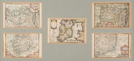
* Ireland. Van den Keere (Pieter). Five Maps of Ireland: The Kingdome of Irland, Connack, Mounster, Ulster [and] Linster circa 1627, five hand-col...
![Ireland. Wyld (James), Ireland [1838]](https://portal-images.azureedge.net/auctions-2023/srdom10230/images/2bf37053-2248-4ffc-8c8f-b0cb010bfd6d.jpg?h=210)
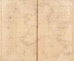
Ireland. Wyld (James), Ireland, published by James Wyld, Geographer to the Queen [1838], very large engraved map on four sheets, sectionalised and...
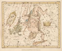
Jamieson (Alexander). A Celestial Atlas Comprising a Systematic Display of the Heavens in a Series of Thirty Maps Illustrated by Scientific Descri...
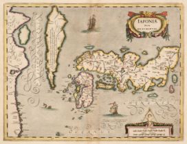
Japan. Mercator (Gerard, Hondius H. & Jansson Jan), Japoniae Nova Descriptio, Amsterdam, circa 1640, hand-coloured engraved map, insular Korea, de...
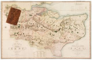
Kent. Greenwood (C.), Map of the County of Kent, from an actual survey made in the years 1819 & 1820, published G. Pringle July 19th, 1821, large ...
La Perouse (Comte Jean de). Atlas du Voyage de la Perouse, circa 1799, title page torn with slight loss, 41 single and double-page engraved maps a...
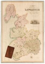
Lancashire. Hennet (G.), A Map of the County Palatine of Lancaster Divided into Hundreds and Parishes from an accurate survey made in the years 18...
London. Homann (J. B. heirs of), Urbium Londini et West-Monasterii..., Nuremberg, circa 1736
London. Homann (Johann Baptiste, heirs of), Urbium Londini et West-Monasterii nec non Surburbii Southwark Accurata Ichnographia..., Neuester Grund...
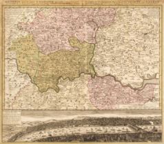
London. Homann (Johann Baptist, Heirs of), Regionis quae est circa Londinum specialis repraesentatio Geographica..., Ausfuhrliche Geographische Vo...
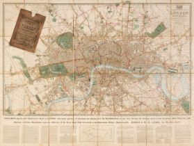
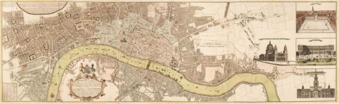
London. Laurie (Richard Holmes), Laurie's New Plan of London and its Environs with an Improved Scale for ascertaining Distances, The Fares of Hack...
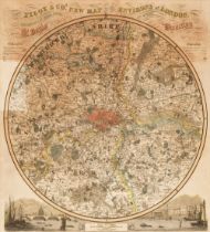
* London. Pigot (James), Pigot & Co.'s New Map of the Environs of London Extending 14 Miles round St. Pauls in every Direction, 1839, circular eng...
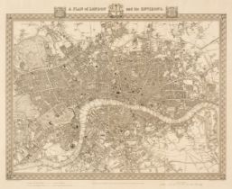
London. Walker (J & C), A Plan of London and its Environs, circa 1830, uncoloured engraved map, originally published in 'Lewis's Topographical Dic...
![Mallet (Alain Manesson). Londres [and] Isle de Wigh, circa 1683](https://portal-images.azureedge.net/auctions-2023/srdom10230/images/610615a1-b581-4993-9cb5-b0cb010c03c9.jpg?h=210)
* Mallet (Alain Manesson). Londres [and] Isle de Wigh, circa 1683, two hand-coloured engraved maps, originally published in the 'Description de l'...
Maps. A collection of 33 British maps, 17th - 19th century, engraved maps, including 23 after Robert Morden, some maps wormed with loss, 6 framed ...
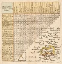
* Middlesex. A collection of 25 maps, 17th - 19th century, engraved county maps, including examples by or after Van Langeren, Luffman, Van den Kee...
![Middlesex. Drayton (Michael). An untitled allegorical map of Middlesex..., [1612 or later]](https://portal-images.azureedge.net/auctions-2023/srdom10230/images/6e50e935-0579-49b6-9053-b0cb010c054e.jpg?h=210)
Middlesex. Drayton (Michael). An untitled allegorical map of Middlesex and Hertfordshire [1612 or later], an uncoloured engraved allegorical map, ...
![Middlesex. Speed (John). Midle-Sex described..., George Humble [1611 - 27]](https://portal-images.azureedge.net/auctions-2023/srdom10230/images/af67257d-ca6f-4825-97c9-b0cb010c05b5.jpg?h=210)
* Middlesex. Speed (John), Midle-Sex described with the most famous Cities of London and Westminster, George Humble [1611 - 27], engraved map with...
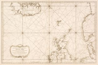
Mount (Richard & William and Page Thomas.). The English Pilot, parts 1 & 3 (bound as one) 1711, part 1 lacking title and preliminaries, 29 uncolou...
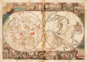
Moxon (Joseph or James). A collection of six Biblical Maps: Untitled double hemisphere map, one hemisphere being celestial, the other terrestrial,...
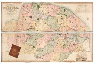
Norfolk. Bryant (Andrew), Map of the County of Norfolk from Actual Survey by A.Bryant in the Years 1824, 1825 and 1826, Respectfully dedicated to ...
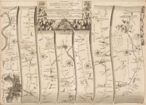
* Ogilby (John). The Road from London to the City of Bristol..., circa 1676, uncoloured engraved strip road map, slight spotting, 335 x 465 mm, re...
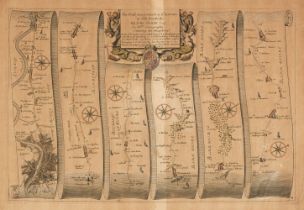
* Ogilby (John). The Road from London to St Davids in com. Pembroke, The Continuation of the Road from London to St. Davids..., Plate ye 2nd, The ...
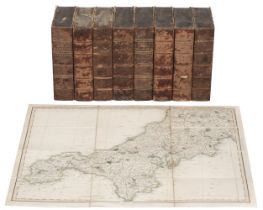
Smith (Charles). Fourteen County Maps, 1804, fourteen (including Yorkshire on 4 sheets) double-page engraved maps, all with contemporary wash colo...
Spain & Portugal. A collection of 18 maps, mostly 17th & 18th century, uncoloured engraved country and regional maps and town plans, including exa...
![Speed (John). Title and Dedication pages, Thomas Bassett & Richard Chiswell [1676]](https://portal-images.azureedge.net/auctions-2023/srdom10230/images/ae10d160-f9fc-453a-a1f9-b0cb010c09f0.jpg?h=210)
* Speed (John). Title and Dedication pages, Thomas Bassett & Richard Chiswell [1676], hand-coloured engraved title & dedication page, each approxi...
Surrey. A collection of 19 folding maps, 18th, 19th & early 20th century, engraved and lithographic folding county and touring maps, including exa...
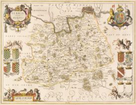
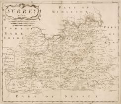
* Surrey. Jansson (Jan), Surria vernacule Surrey, Amsterdam, circa 1648, hand-coloured engraved map, decorative cartouche and mileage scale, 385 x...
Title Pages. Four Title pages, 17th & 18th century, four engraved title pages, three with contemporary hand-colouring, with examples by or after D...
Walker (J. & C., publishers). Hobson's Fox-Hunting Atlas containing separate Maps of every County in England and the three Ridings of Yorkshire, J...