Refine your search
Estimate
Category
Creator / Brand
- Robert Morden (7)
- Mercator (6)
- Christopher Saxton (5)
- Gerard Mercator (5)
- John Speed (5)
- Herman Moll (3)
- Thomas Kitchin (3)
- English School (2)
- Jacques Nicolas Bellin (2)
- Jodocus Hondius (2)
- John Cary (2)
- William Hogarth (2)
- Albrecht Dürer (1)
- Blaeu (1)
- Bourguignon D'Anville (1)
- Emanuel Bowen (1)
- England (1)
- Everton (1)
- Frederik de Wit (1)
- French School (1)
- Henricus Hondius (1)
- Johannes van Keulen II (1)
- John Barrow (1)
- John Ogilby (1)
- John Rocque (1)
- John Senex (1)
- Kensitas Club Cigarettes (1)
- Peter Paul Rubens (1)
- Pierre Mortier (1)
- Ptolemy (1)
- Rembrandt (1)
- Richard Jackson (1)
- Scotland (1)
- Sebastian Munster (1)
- Sheffield Wednesday (1)
- Thomas Bowen (1)
- Thomas Moule (1)
- Van Keulen (1)
- Wenceslaus Hollar von Prachna (1)
Item Type
- Map (76)
- Cartographers and Mapmakers (20)
- Engraving (15)
- Etching (9)
- Book (8)
- 15th-18th Century Art (5)
- Letter (4)
- Lithograph (4)
- Postcard (3)
- Programme (3)
- Road map (3)
- Dictionary (2)
- Magazine (2)
- Magazines (2)
- Oleograph (2)
- Ordnance survey map (2)
- Photograph album (2)
- Portrait (2)
- Sport (2)
- Autograph (1)
- Bible (1)
- Celestial Chart (1)
- Contemporary Art (1)
- Cricket (1)
- Cricket Memorabilia (1)
- Encyclopedia (1)
- Folio (1)
- Football (1)
- Football Memorabilia (1)
- Football Teams & Brands (1)
- Manual (1)
- Manuals (1)
- Road map (1)
- Scotch (1)
- Scotch whisky (1)
- Spirits (1)
- Sports Autograph (1)
- Sports Autographs, Photos, & Posters (1)
- Sports Programme (1)
- Whisky (1)
- List
- Grid
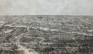

Nathaniel Whittock (British 1791-1860): 'Bird's Eye View of the City of York', 1st or 2nd edition, 19th century lithograph by John Storey, in bird...
William Hole (British fl.c.1601-1624) and Christopher Saxton (British c1540-c 1610): 'Eboracensis Co
William Hole (British fl.c.1601-1624) and Christopher Saxton (British c1540-c 1610): 'Eboracensis Comitatus pars Occidentalis vulgo West Riding', ...
William Hole (British fl.c.1601-1624) and Christopher Saxton (British c.1540-c. 1610): 'Eboracensis
William Hole (British fl.c.1601-1624) and Christopher Saxton (British c.1540-c. 1610): 'Eboracensis Comitatis pars Occidentalis vulgo West Riding'...
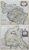
Robert Morden (British c.1650-1703): 'The East Riding' and 'West Riding of Yorkshire', pair 18th century engraved maps with hand-colouring 36cm x ...
Robert Morden (British c.1650-1703): 'The East Riding of Yorkshire', 17th century engraved map with hand-colouring pub. 1695, 36cm x 42cm
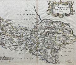
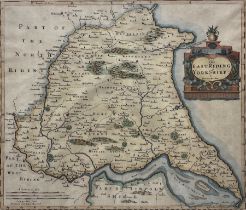
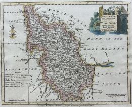
Robert Morden (British c.1650-1703): 'The North Riding of Yorkshire', 18th/19th century engraved map with hand-colouring 35cm x 41cm
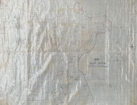
J Lane (Surveyor) (British 19th century): 'Plan of the Keldy Estate 1891', original 19th century hand-drawn map and plan of the Keldy Estate in th...
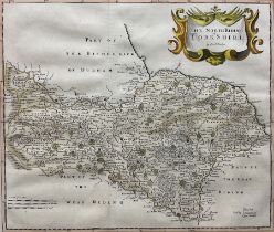
Robert Morden (British c.1650-1703): 'The North Riding of Yorkshire', 17th/18th century engraved map with hand-colouring 36cm x 41cm
Joseph Ellis (British 18th century): 'A Modern Map of the West Riding of Yorkshire', 18th century engraved map with hand-colouring; 19th century l...
John Senex (British 1678-1740): 'The Roads from York to Scarborough and Whitby', pair 18th century engraved maps with hand colouring, pub. 'An Act...
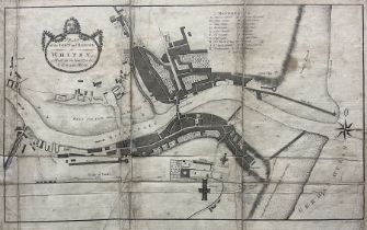
L Charlton (British 18th century): 'Plan of the Town and Harbour of Whitby', 18th century engraved map with hand-colouring pub. c.1778, 28cm x 48cm
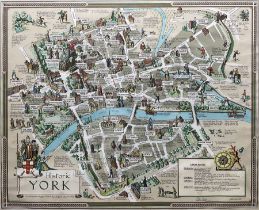
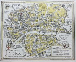
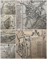
Estra Clark (British 1904-1993): 'Historic York', colour map pub. Ben Johnson & Co Ltd. York 1947, signed in pen 55cm x 67cm
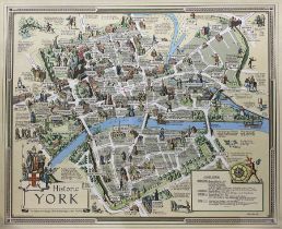
After Estra Clark (British 1904-1993): 'Historic York', map pub. Ben Johnson & Co, York 1947, 37cm x 45cm
After Estra Clark (British 1904-1993): 'Historic York', colour map pub. Ben Johnson & Co Ltd. York 1947, 55cm x 67cm
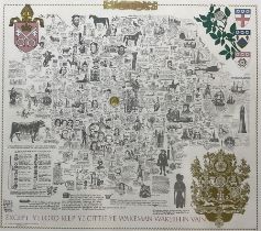
After James Joseph Lloyd Carr (British 1912-1994): Literary and Historical Map of 'Yorkshire'
After James Joseph Lloyd Carr (British 1912-1994): Literary and Historical Map of 'Yorkshire', limited edition indistinctly numbered dedicated to ...

Joseph Lloyd Carr (British 1919-1994): 'Worcestershire', limited edition 20th century printed map numbered 460/572 together with 'York - Monarchs,...
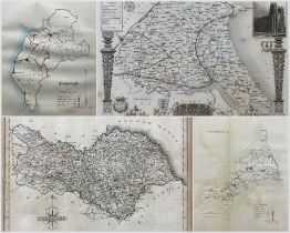
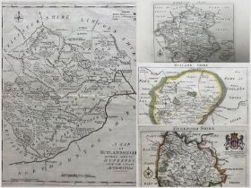
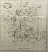
John Cary (British 1755-1835): North Riding of Yorkshire, 19th century engraved map with hand colouring originally pub. 1787 together with various...
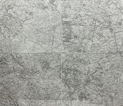
Early 20th century OS map of Yorkshire from Wakefield to Thorne 61cm x 72cm
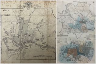
Thomas Jefferys (British c1719–1771): 'A Plan of Leeds surveyed by Thomas Donald', 19th century engraved map originally pub. c.1771 with later fra...
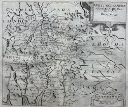
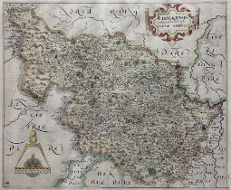
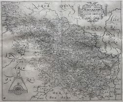
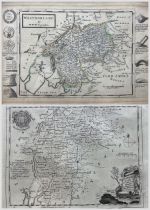
Christopher Saxton (British c1540-c1610) and William Kip (British 1588-1635): 'Westmorlandiae Comita
Christopher Saxton (British c1540-c1610) and William Kip (British 1588-1635): 'Westmorlandiae Comitatus qui olim Spectauit ad Brigantas', 17th cen...
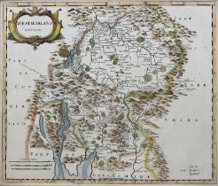
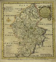
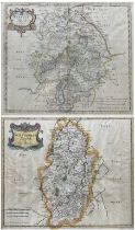
Robert Morden (British c.1650-1703): 'Westmorland', 17th/18th century engraved map with hand-colouring pub. 'Camden's Britannia' London c.1695, 37...
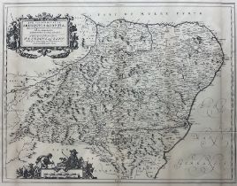
Herman Moll (Dutch/British 1654-1732): 'Westmorland', engraved map with hand-colouring and a border of antiquarian finds pub. c.1747; Thomas Kitch...
Robert Gordon of Straloch (Scottish 1580-1661): 'Aberdonia & Banfia' - Aberdeenshire and Banffshire
Robert Gordon of Straloch (Scottish 1580-1661): 'Aberdonia & Banfia' - Aberdeenshire and Banffshire, 19th century engraved map (1870 edition) orig...
John Speed (British 1552-1629): Inset Town Plans of 'Hull' 'Warwicke (Warwick)' 'Norwiche (Norwich)'
John Speed (British 1552-1629): Inset Town Plans of 'Hull' 'Warwicke (Warwick)' 'Norwiche (Norwich)' 'Southampton' 'Buckingham' and 'Lancaster', s...
John Rocque (French/British 1704-1762) : 'Herefordshire' 'Worcestershire' and 'Rutlandshire'
John Rocque (French/British 1704-1762) : 'Herefordshire' 'Worcestershire' and 'Rutlandshire', three 18th century engraved maps two with hand-colou...
Emmanuel Bowen (British 1694-1767): 'The Road from London to Boston, commencing at Stilton', 18th century engraved map with hand colouring with 'T...
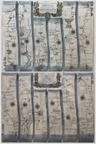
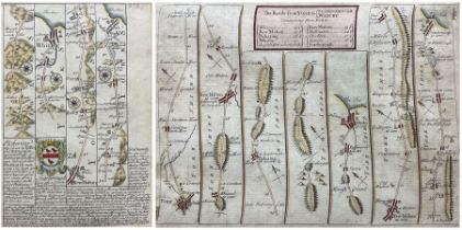
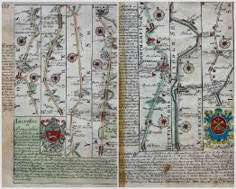
John Ogilby (Scottish 1600-1676): 'The Road from Bristol to Chester' and 'The Continuation...'
John Ogilby (Scottish 1600-1676): 'The Road from Bristol to Chester' and 'The Continuation...', pair 17th century engraved strip road maps with ha...
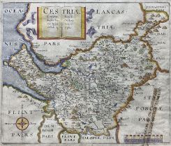
William Hole (British fl.c.1601-1624) and Christopher Saxton (British c1540-c 1610): 'Cestriae'
William Hole (British fl.c.1601-1624) and Christopher Saxton (British c1540-c 1610): 'Cestriae', 17th century engraved map with hand-colouring of ...
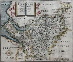
William Hole (British fl.c.1601-1624) and Christopher Saxton (British c1540-c 1610): 'Cestriae'
William Hole (British fl.c.1601-1624) and Christopher Saxton (British c1540-c 1610): 'Cestriae', 17th century engraved map with hand-colouring of ...
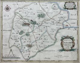
Robert Morden (British c.1650-1703): 'Comitatus Rotelandiae tabula Nova & Aucta' (Rutland), 17th/18th century engraved map with hand-colouring pub...
Emanuel Bowen (British 1694-1767): 'Staffordshire', 19th century engraved map with hand-colouring together with two Christopher Saxon reproduction...
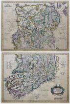
Henricus Hondius (Dutch 1597-1651): 'Hibernia Pars Australis' and Pars Borealis, pair 17th century engraved maps of the Northern and Southern halv...
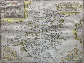
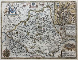
John Speed (British 1552-1629): 'Montgomery Shire', 17th century engraved map of Montomeryshire Wales with hand-colouring 39cm x 52cm
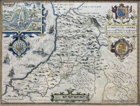
John Speed (British 1552-1629): 'Cardigan Shyre described with the due forme of the Shire-town'
John Speed (British 1552-1629): 'Cardigan Shyre described with the due forme of the Shire-town', 17th century engraved map of the Ancient Welsh Co...
John Speed (British 1552-1629): 'The Bishoprick and Citie of Durham', 17th century engraved map with hand-colouring pub. Thomas Bassett & Richard ...
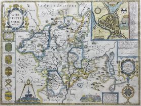
John Speed (British 1552-1629): 'Worcestershire Described', 17th century engraved map with hand-colouring pub. Thomas Bassett & Richard Chiswell c...
T Nash (British 18th century): 'Worcestershire', rare 18th century engraved folding map pub. 'History of Worcestershire' 1781, 56cm x 52cmConditio...
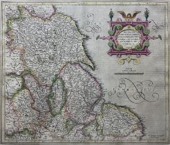
Gerard Mercator (Flemish 1512-1594): 'Eboracum Lincolnia Derbia, Staffordia Notinghamia Lecestria Rutlandia et Norfolcia', early 17th century engr...
Robert Morden (British c.1650-1703): 'Nottinghamshire' and 'Warwickshire', two 17th/18th century engraved maps with hand-colouring 38cm x 45cm (2)
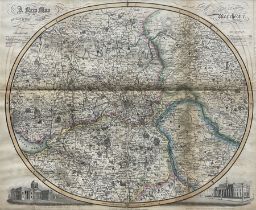
James Pigot (British 1769-1843): 'A New Map of The Manufacturing District - Manchester', 19th century engraved map with hand-colouring pub. 1841, ...
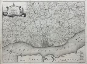
William Yates (British 1738-1802) and George Perry (British c.1718-1771): 'The Environs of Liverpool
William Yates (British 1738-1802) and George Perry (British c.1718-1771): 'The Environs of Liverpool Drawn From an Actual Survey Taken in the Year...
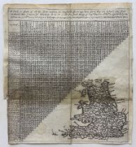
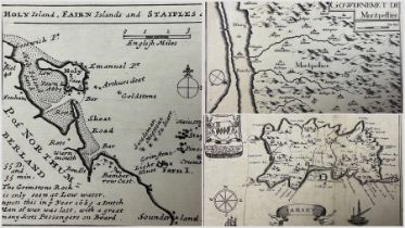
Probably Jacob Van Langeren (Dutch 17th century): 'A Card, or platt, of all the shire townes in England shewinge how farre they are distant one fr...
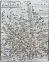
Herman Moll (British 1654-1732): 'A New Mapp of the Roads of England', 17th century engraved map pub. c.1699, 26cm x 20cm
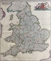
Frederik de Wit (Dutch 1629-1706): 'Anglia Regnum in Omnes Suos Ducatus Comitatus et Provincias Divi
Frederik de Wit (Dutch 1629-1706): 'Anglia Regnum in Omnes Suos Ducatus Comitatus et Provincias Divisum', 17th century engraved map with hand-colo...
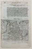
Gerard Mercator (Flemish 1512-1594): 'Anglia', 16th century map of England with text, pub. c.1595, 31cm x 20cm
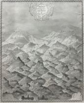
Thomas Moule (British 1784-1851): 'A Comparative View of some of the Principal Hills in Great Britai
Thomas Moule (British 1784-1851): 'A Comparative View of some of the Principal Hills in Great Britain', 19th century engraved topographic map pub....
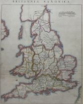
John Rapkin (British 1813-1899): Britannia Saxonica, 19th/20th century engraved map with later hand colouring originally pub. c1850, 39cm x 30cm
Richard Blome (British 1635-1705): 'Jarsey' - Jersey, 18th century engraved map pub. Britannia: or, A Geographical Description of the Kingdoms of ...
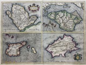
Jodocus Hondius (Flemish 1563-1612): 'Anglesey Garnesay Wight olim vectis and Jarsay', 16th/17th century engraved map of the British Channel Islan...
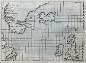
English School (18th century): North-West Passage with Great Britain Iceland and Greenland, 18th century engraved map or sea chart pub. John Gaton...
Johannes Van Keulen (Dutch 1654-1715): 'Zeekaart van t’derde Gedeelte Van t’ Canaal Tusschen Engelan
Johannes Van Keulen (Dutch 1654-1715): 'Zeekaart van t’derde Gedeelte Van t’ Canaal Tusschen Engeland en Vrankryk', 17th century engraved map or s...
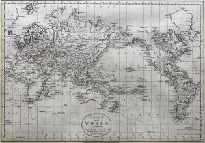
Russell Junior (British 18th century): 'Chart of the World according to Mercators Projection Shewing
Russell Junior (British 18th century): 'Chart of the World according to Mercators Projection Shewing the Tracks & Discoveries of Captain Cook', 18...
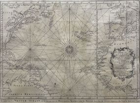
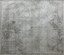
Jacques Nicolas Bellin (French 1703-1772): 'Kaart van den Wester-Oceaan, om te dienen voor de Historische Beschryving', 18th century engraved map ...
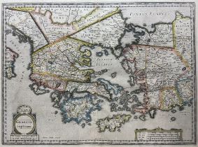
Jodocus Hondius (Flemish 1563-1612): 'Hellas Graecia Sophiani', 16th/17th century engraved map of Greece with hand-colouring, pub. Gerard Mercator...
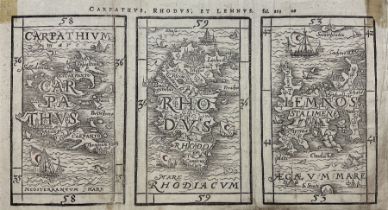
Heinrich Petri (Swiss 1508-1579): 'Carparthus Rhodus et Lemnus', 16th century engraved map of the Greek Islands Carparthos Rhodes and Lemnos, pub....
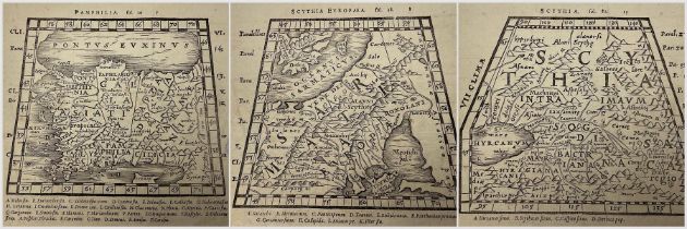
Sebastian Munster (German 1482-1552): 'Scythia Europaea' 'Scythia' and 'Pamphilia', set three 16th century engraved maps pub. 'Ptolemy's Geographi...
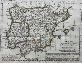
Jean-Baptiste Bourguignon d'Anville (French 1697-1782): 'Spain', 18th century engraved map with later hand colouring pub. Roman History from the F...
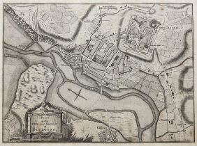
English School (18th century): 'Plan of the Town and Harbour of Boulogne', 18th century engraved map of Boulogne-sur-Mer - France pub. John Barro...
Pierre Mortier (French 1661-1711): Map of France with Duches, engraved map with hand colouring pub. c.1680, 43cm x 57cm
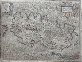
Giovanni Antonio Magini (Italian 1555-1617): 'Isola Di Sardegna', 17th century engraved map with hand-colouring pub. 'Italy' c.1620, 36cm x 46cm