


Ray-Ban Unisex Sunglasses Black Round Double Bridge Black Frame- appear unworn examples with as pictured all relevant original paperwork and packa...
Collectables Auctions
Explore an enormous array of collectables auctions on the UK's leading online auction marketplace. Browse models, toys, dolls, games, arms, armour, militaria, books & periodicals, sporting equipment & memorabilia, musical instruments, stamps, coins, classic cars & motorcycles, camera & camera equipment, wines & spirits, maps, religious items & folk art, banknotes, entertainment memorabilia, and more. With so many reputable auction houses selling on the saleroom, you can find the collectables auctions you're looking for and more. Use tools like watch lists, auction alerts, filters, and more to speed up your search and compete in live and timed auctions. Place winning bids on the items that match your criteria and get your next collectable on the saleroom.
Popular categories
Musical Instruments & Memorabilia
Bank Notes
Cameras & Photography Equipment
Entertainment Memorabilia
Kitchenalia
Toys & Games
Railwayana
Religious Items & Folk Art
Scientific Instruments
Writing Instruments
Sports Memorabilia & Equipment Auctions
Collectable Stamps
Tools
Taxidermy
Arms, Armour & Militaria
Vintage Wine & Spirits
Featured auctions
Upcoming auctions

116 item(s)
Filtered by:
- Category,
- Auction Type
- List
- Grid
-
116 item(s)/page

Eight mid century canvas backed wall maps, Europe; the World; England & Wales; N. America; S. America; Asia; Africa; Palestine. Estimate: £20-40. ...

Lot 16
SPEED (JOHN) The Kingdome of China Newly Augmented by I.S. 1626, Thomas Bassett and Richard Chis...
SPEED (JOHN) The Kingdome of China Newly Augmented by I.S. 1626, hand-coloured engraved map, decorated borders with eight costumed figures in ve...
![SPEED (JOHN) Yorkshire; The North and East Ridins of Yorkshire; West Ridinges, [c.1730], hand-co...](https://portal-images.azureedge.net/auctions-2024/bonham10855/images/38d5b31b-fc81-4c30-82bb-b179011a54ac.jpg?w=155&h=155)
Lot 24
SPEED (JOHN) Yorkshire; The North and East Ridins of Yorkshire; West Ridinges, [c.1730], hand-co...
SPEED (JOHN) Yorkshire; The North and East Ridings of Yorkshire, inset plans of Hull and Richmond ; The West Ridinge of Yorkeshyre with Most Fam...

Lot 124
AFRICA MUNSTER (SEBASTIAN) Africa Lybia Morenlandt mit allen königreichen so zu unsern zeit...
AFRICA MUNSTER (SEBASTIAN) Africa Lybia Morenlandt mit allen königreichen so zu unsern zeiten darin gefunden werden, hand-coloured woodcut map, ...
![AFRICA BLAEU (WILLEM) Africae nova descriptio, [c. 1630 or later]](https://portal-images.azureedge.net/auctions-2024/bonham10791/images/d70693cb-2c26-42a3-9d72-b17a010d6222.jpg?w=155&h=155)
AFRICA BLAEU (WILLEM) Africae nova descriptio, hand-coloured engraved double-page map, 10 costumed figures on the vertical margins and 9 oval vi...

Lot 132
EAST AFRICA DE WIT (FREDERICK) Occidentalior Tractus Indiarum Orientalium a Promontorio Bonae Sp...
EAST AFRICA DE WIT (FREDERICK) Occidentalior Tractus Indiarum Orientalium a Promontorio Bonae Spei ad C. Comorin, hand-coloured engraved double-...

Lot 22
SOCIETY FOR THE DIFFUSION OF USEFUL KNOWLEDGE The Complete Atlas of Modern, Classical and Celest...
SOCIETY FOR THE DIFFUSION OF USEFUL KNOWLEDGE The Complete Atlas of Modern, Classical and Celestial Maps, together with Plans of the Principal Cit...

Lot 128
AFRICA DE WIT (FREDERICK) Totius Africae Accuratissima Tabula,Amsterdam, Frederick de Wit, [c.16...
AFRICA DE WIT (FREDERICK) Totius Africae Accuratissima Tabula, hand-coloured double-page engraved map, decorative title cartouche, animal vignet...

Lot 3
BLAEU (WILLEM AND JAN) Toonneel des Aerdrycz, oft Nieuwe Atlas... Tweede Deels, 2 parts in 1 vol...
3BLAEU (WILLEM AND JAN) Toonneel des Aerdrycz, oft Nieuwe Atlas... Tweede Deels, 2 parts in 1 vol...
BLAEU (WILLEM AND JAN) Toonneel des Aerdrycz, oft Nieuwe Atlas... Tweede Deels, 2 parts in 1 vol., engraved architectural and allegorical titles...

DURHAM, The Bishoprieke and Citie of Durham. Hand coloured map, by John Speed, attractively f&g, circa 1610, with English text in the verso, 37.5c...

A collection of seven 20th century Conic Projection maps together with another. The lot to include: the map of Iran (Persia) scale 1:4,000,000 pla...

Lot 15
Assorted books
Assorted books inc. Building Construction, Drainage Sanitation, Voyage Round the World, Legends of Monastic Orders, Holy Sacrament 1701 and 3 Ordn...

Lt Col. Valentine Blacker CB. (British, 1778-1826) Satara from the NNE inscribed and dated '11th February 1818' pen & ink 23 x 14cm (9 1/16 ...

AFRICA HONDIUS (HENRICUS) Africae nova Tabula, double-page hand-coloured engraved map, numerous ships, sea-monsters, animals (elephants, lions, ...

Lot 130
WEST AFRICA DE WIT (FREDERICK) Tractus Littorales Guineae a Promontorio Verde usque ad Sinum Cat...
WEST AFRICA DE WIT (FREDERICK) Tractus Littorales Guineae a Promontorio Verde usque ad Sinum Catenbelae, hand-coloured engraved double-page map,...

Lot 131
ETHIOPIA ORTELIUS (ABRAHAM) Presbiteri Iohannis, sive, Abissinorum Imperii Descriptio, [1573 or ...
ETHIOPIA ORTELIUS (ABRAHAM) Presbiteri Iohannis, sive, Abissinorum Imperii Descriptio, hand-coloured engraved double-page map, large cartouche w...
![CHATELAIN (HENRY ABRAHAM)] Atlas historique... vol. 6 (with Africa section only), 1719; and 3 ot...](https://portal-images.azureedge.net/auctions-2024/bonham10791/images/042d00a5-0aa0-4a70-95b3-b17a010d9cce.jpg?w=155&h=155)
Lot 156
CHATELAIN (HENRY ABRAHAM)] Atlas historique... vol. 6 (with Africa section only), 1719; and 3 ot...
[CHATELAIN (HENRY ABRAHAM)] Atlas historique, ou nouvelle introduction a l'histoire..., vol. 6 (with Africa section only), title printed in red ...

Lot 211
THAILAND AND EAST ASIA TACHARD (GUY) Reis Na Siam, Amsterdam, A.D. Oossaan, 1687; and 11 others ...
THAILAND and EAST ASIA TACHARD (GUY) Reis Na Siam edaan door den Ridder de Chaumont, in't Nederduitsch gebracht door G. V. Broekhuizen, addition...

Lot 4
BLAEU (WILLEM AND JAN) Toonneel des Aerdrycks oft Nieuwe Atlas...Vierde Deel, Amsterdam, Jan Bla...
4BLAEU (WILLEM AND JAN) Toonneel des Aerdrycks oft Nieuwe Atlas...Vierde Deel, Amsterdam, Jan Bla...
BLAEU (WILLEM AND JAN) Toonneel des Aerdrycks oft Nieuwe Atlas...Vierde Deel, engraved title and 58 engraved maps, marginal damp-staining, small...

SOUTHERN AFRICA. SANSON, Nicholas. Basse Aethiopie, Paris 1655, a hand coloured engraved map, draped title cartouche, creases, crinkles, cropped, ...

MORDEN, Robert. The County Palatine of Chester,1695 or later, hand coloured engraved map, some discolouration, 35cm x 42cm.

A collection of 22 Ordnance Survey WWII C.1940 Great Britain Maps

TR16305 † A map of Africa, in a glazed and ebonized frame. H.102 W.79cm.

Lot 127
AFRICA L'Afrique suivant les dernières observations de M. Hass... Paris, Georges-Louis Le R...
AFRICA L'Afrique suivant les dernières observations de M. Hass et des RR. PP. Jésuites, engraved map with hand-coloured outlines, light toning,4...
![WEST AFRICA HONDIUS (JODOCUS) Guineae Nova Descriptio, [Amsterdam, after 1619]; BLAEU (WILLEM) G...](https://portal-images.azureedge.net/auctions-2024/bonham10791/images/60cf56e9-8579-461d-a2ef-b17a010d721a.jpg?w=155&h=155)
Lot 129
WEST AFRICA HONDIUS (JODOCUS) Guineae Nova Descriptio, [Amsterdam, after 1619]; BLAEU (WILLEM) G...
WEST AFRICA HONDIUS (JODOCUS) Guineae Nova Descriptio, hand-coloured engraved double-page map, title cartouche and inset map of St. Thomas, Fren...

Lot 133
ETHIOPIA, SOUTH AFRICA AND MADAGASCAR BLAEU (WILLEM) Aethiopia Superior vel Interior, [Amsterdam...
ETHIOPIA, SOUTH AFRICA AND MADAGASCAR BLAEU (WILLEM) Aethiopia Superior vel Interior vulgo Abissinorum sive Presbiteri Joannis Imperium, hand-co...

Lot 149
BERNADIN DE SAINT PIERRE (JACQUES) A Voyage to the Isle of France, the Isle of Bourbon, and the ...
BERNADIN DE SAINT PIERRE (JACQUES) A Voyage to the Isle of France, the Isle of Bourbon, and the Cape of Good Hope, half-title, 4 hand-coloured f...

Lot 199
ROGERS (WOODES) A Cruising Voyage Round the World: First to the South-Sea, thence to the East-In...
ROGERS (WOODES) A Cruising Voyage Round the World: First to the South-Sea, thence to the East-Indies, and Homewards by the Cape of Good Hope, Begu...

Lot 23
SPEED (JOHN) AND WILLEM BLAEU Pictorial title-pages to Speed's 'Theatre of the Empire of Great B...
SPEED (JOHN) AND WILLEM BLAEU Pictorial title-pages to Speed's 'Theatre of the Empire of Great Britain', 1650, and Blaeu's 'Le Théâtre du Monde......

Lot 20
NORFOLK and SUFFOLK - SPEED (JOHN) Norfolk and Sufolk, 2 double-page engraved maps with outline ...
NORFOLK and SUFFOLK SPEED (JOHN) Norfolk, a Countie Florishing & Populous Described and Devided with the Armes of such Noble Familes as have Borne...
![BLAEU (JAN) Delfi Batavorum vernacule Delft, [Amsterdam, 1649 or later]; BLAEU (WILLEM) Novus X...](https://portal-images.azureedge.net/auctions-2024/bonham10855/images/73460c6e-1380-48e8-bc29-b179011a54d5.jpg?w=155&h=155)
Lot 2
BLAEU (JAN) Delfi Batavorum vernacule Delft, [Amsterdam, 1649 or later]; BLAEU (WILLEM) Novus X...
BLAEU (JAN) Delfi Batavorum vernacule Delft, hand-coloured engraved double-page plan of the city of Delft, Latin text on verso, remnants of arch...

BRICE, Germain. Description de la Ville de Paris et de Tout ce Qu'elle contient de plus remarquable..., Sixie'me Edition., Paris: Francois Fournie...

SANTINI, Paolo. Nouvelle Carte De L'Etat De L'Eglise, Dressée sur Celle Du P. Boscovich, engraved map of Rome and district, title contained within...

MORDEN, Robert. Hampshire, hand coloured map, in an attractive modern frame, good colouring, 42cm x 37cm.

SHARPE, John (publisher). [Sharpe's Corresponding Atlas], Chapman & Hall circa 1847, lacking title and preliminaries, 19 maps (only, of 54), some ...

Title: Weymouth Dorchester Wimborne Antique Railway Junction Map-79. Description: Weymouth Dorchester Wimborne Antique Railway Junctio...

Title: Dorset Coast Weymouth Portland John Cary's Antique 230 Yrs Old Map-5. Description: Dorset Coast Weymouth Portland John Cary's A...

Title: East Anglia Norfolk Suffolk John Cary's Antique 230 Yrs Old Map-35. Description: East Anglia Norfolk Suffolk John Cary's Antiqu...

Title: Isle Of Wright St Lawrence Niton Chale John Cary's Antique 230 Yrs Old Map. Description: Isle Of Wright St Lawrence Niton Chale...

Title: Newcastle Gateshead Chester Le Street Antique King George III 1794 Map. Description: Newcastle Gateshead Chester Le Street Anti...

Title: Dorsetshire Steel Engraved Victorian Antique Thomas Moule Map. Description: Dorsetshire Steel Engraved Victorian Antique Thomas...

Title: County of Essex Steel Engraved Victorian Antique Thomas Moule Map . Description: County of Essex Steel Engraved Victorian Antiq...

Title: County Cheshire Steel Engraved Victorian Antique Thomas Moule Map. Description: County Cheshire Steel Engraved Victorian Antiqu...

Title: Shropshire Steel Engraved Victorian Antique Thomas Moule Map. Description: Shropshire Steel Engraved Victorian Antique Thomas M...

Title: Job lot Antique Copper Engraved George IV Map by Sidney Hall-1 Description: Job lot Antique Copper Engraved George IV Map by Si...

Title: Job lot Antique Copper Engraved George IV Map by Sidney Hall-2. Description: Job lot Antique Copper Engraved George IV Map by S...

Lot 872
After Robert Morden (1650-1703, British cartographer), antiquarian map, 'Northamptonshire', framed
After Robert Morden (1650-1703, British cartographer), antiquarian map, 'Northamptonshire', framed and under glass, measuring 38cm x 42cm, & 42cm ...

Lot 874
Matthew Ellwood (20th Century), coloured print, 'Tower of the Yorkshire Dales', framed and mounted,
Matthew Ellwood (20th Century), coloured print, 'Tower of the Yorkshire Dales', framed and mounted, measuring 30cm x 40cm, & 44cm x 55cm overall

Lot 126
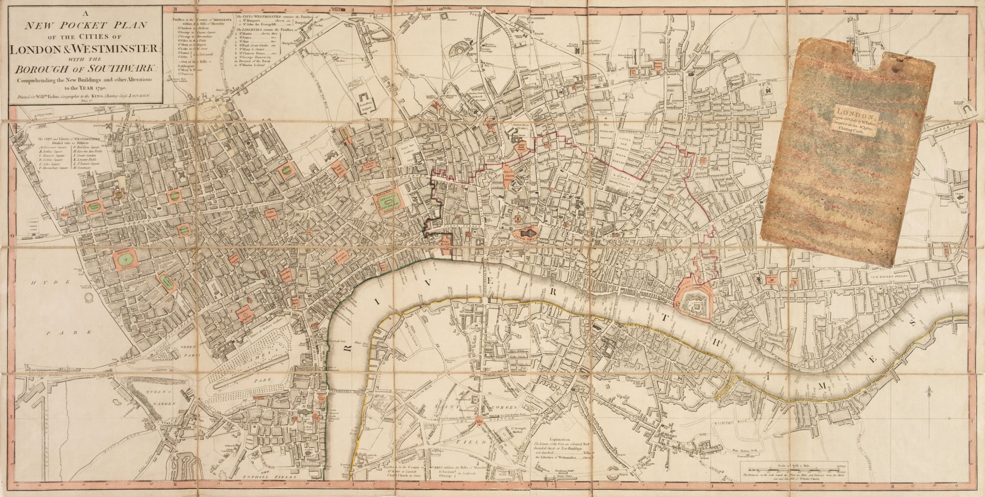
LONDON STOW (JOHN) A Survey of the Cities of London and Westminster... Corrected, Improved, and ...
LONDON STOW (JOHN) A Survey of the Cities of London and Westminster... Corrected, Improved, and Very Much Enlarged... to the Present Time; by John...

Lot 14
GRAY (O.W.) Gray's Atlas of the United States, with General Maps of the World, Philadelphia, Ste...
GRAY (O.W.) Gray's Atlas of the United States, with General Maps of the World, numerous hand-coloured lithographed maps (some double-page, usual...

Lot 451
After Joshua Archer (1792-1863, British), a hand coloured map of Devonshire, framed, mounted, and
451After Joshua Archer (1792-1863, British), a hand coloured map of Devonshire, framed, mounted, and
After Joshua Archer (1792-1863, British), a hand coloured map of Devonshire, framed, mounted, and under glass, measuring 19cm x 23cm, & 35cm x 38c...

After Peter J.Sterkenburg (Dutch,1955-2000), 'Dutch Harbour entrance of Harlingen (important commercial harbour town in the Netherlands between (1...

Lot 198
Modern Reproduction of an antique map of the Cayman Islands. framed and glazed approximately 87 x
198Modern Reproduction of an antique map of the Cayman Islands. framed and glazed approximately 87 x
Modern Reproduction of an antique map of the Cayman Islands. framed and glazed approximately 87 x 67cm

Cricket interest print, Pavilion End D E West, approximately 68 x 48 cm framed and glazed

Framed map of Mannheim buildings etc. 36cm x 43cm

Framed map of district of Munich, 36cm x 40cm

Framed map 'Gallia VETVS Abrah Ortelii' of France 35cm x 44cm

Lot 35
A Rosewood framed map of Sicily, titled A Map of Ancient Sicele mentioned in Polybious 1692, frame
35A Rosewood framed map of Sicily, titled A Map of Ancient Sicele mentioned in Polybious 1692, frame
A Rosewood framed map of Sicily, titled A Map of Ancient Sicele mentioned in Polybious 1692, frame 41cm x 48cm, map 18cm x 23cm

A box containing a quantity of maps and one large map of UK